

Orlando weather: Another muggy and potentially stormy afternoon for Central Florida
MONDAY: Similar weather to begin the week with hot and humid weather and afternoon storms likely. Best chance of rain remains in inland areas between 1-7 pm. Highs will climb into the low to mid 90s with feels like temps ranging from 104-107.
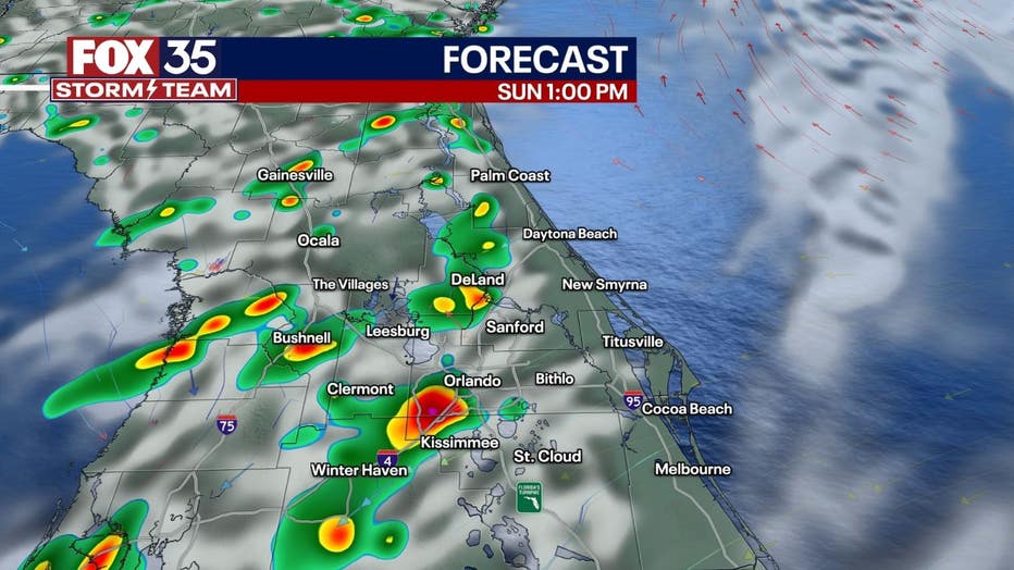
REST OF THE WEEK : Through midweek, we continue with likely afternoon storm chances and highs in the 90s. By Independence Day, we could see slightly drier air lower rain chances heading into the holiday weekend. Unfortunately, we will trade the rain chances for even warmer highs in areas with mid 90s common place and dangerous afternoon heat index values.
TROPICS: Beryl has continued to strengthen in the Central Atlantic and is now the first Category 4 hurricane to ever form in the month of June. It remains on track to threaten the Windward Islands of Barbados, St. Vincent and the Grenadines, and St. Lucia as a dangerous Category 4 storm.
Life-threatening winds and storm surge are possible by early Monday for these islands. It is then forecast to move into the Caribbean and continue northwestward as a strong hurricane. Most models keep it south of the Greater Antilles, but forecast it to reach Jamaica and the Caymans by late Wednesday/Thursday as a Category 2 hurricane or weak Category 3 storm.
Wind shear should help weaken it some the farther west it goes with potential for hurricane impacts in the Yucatan. In the longer range, there is potential for it to continue into the Bay of Campeche. It is too soon to say where it will go from there, but those along the Gulf coast from Louisiana to Texas should watch it closely.
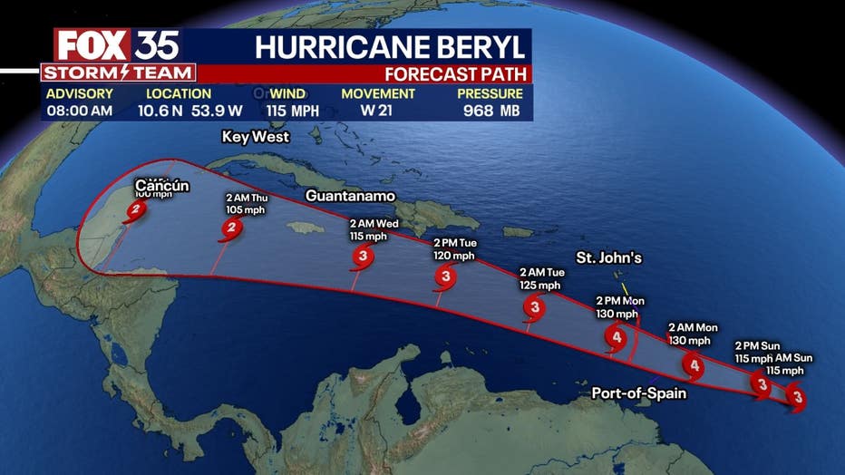
This afternoon Tropical Depression Three formed in the Bay of Campeche and is forecast to become a tropical storm late tonight before moving onto the Mexican coast. It would become Chris if it were to reach tropical storm status.
Meanwhile, just behind Beryl, another tropical wave (96L) has a decent chance to become another named system and may become "Debby" sometime late this week. It is forecast to follow the path of Beryl. Models indicate that it would likely be a weaker storm, but could still become a hurricane as it nears the Lesser Antilles and moves into the Caribbean.
Overall, our summer wet season is in full swing and earlier forecasts for an extremely busy hurricane season are in the early stages of coming to fruition.