

Sunny, cool temperatures for Central Florida ahead of week
ORLANDO, Fla. - It's slated to be a nice and sunny Sunday before we head into the work week!
TONIGHT: Partly cloudy skies and cool temperatures are on tap through the overnight tonight. Lows will be in the mid 60s tonight.
WEATHER BREAKDOWN: High pressure at the surface continues to dominate, making for lots of sunshine to start our Sunday. We'll likely see clouds bubbling in the heating of the day with the help of some lift overhead. This weak disturbance still impacts us today with the threat for isolated downpours. Most will stay dry, just like our Saturday. As we get into the ridge of high pressure upstairs in the atmosphere, we'll see more sun on Monday. It'll also be warmer as a result.
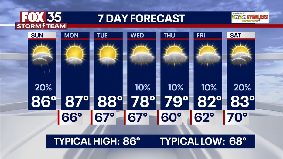
Highs spike back into the upper 80s and that warming continues into Tuesday. That hotter feel streams in ahead of a cold front hat comes through mainly dry later Tuesday. We could see a couple of showers overnight into Wednesday but chances are low. Bigger story is the cooldown with highs dropping around 10 degrees into midweek. Lows dip back into the upper 50s and lower 60s Thursday AM! It'll be gorgeous with dew points likely near 60 degrees. That's the first time since late April...at least for MCO. We'll keep the potential for an isolated shower Thursday and Friday but chances rise just a little by next weekend. A disturbance aloft with likely a stalled boundary reflected at the surface could make for a few downpours Saturday and Sunday. Temps look to return to seasonable levels with a bit more humidity as well.
TROPICS: A 40% chance of development off the West Coast of Africa over the next 7-days.
Where the hype from social media comes from is that, yes, climatologically we see development start to shift from the eastern Atlantic to development in the gulf and Caribbean in the month of October, however, it is one of those years that we are still seeing development potential off the coast of Africa and Invest 94L will continue to make its way westward.
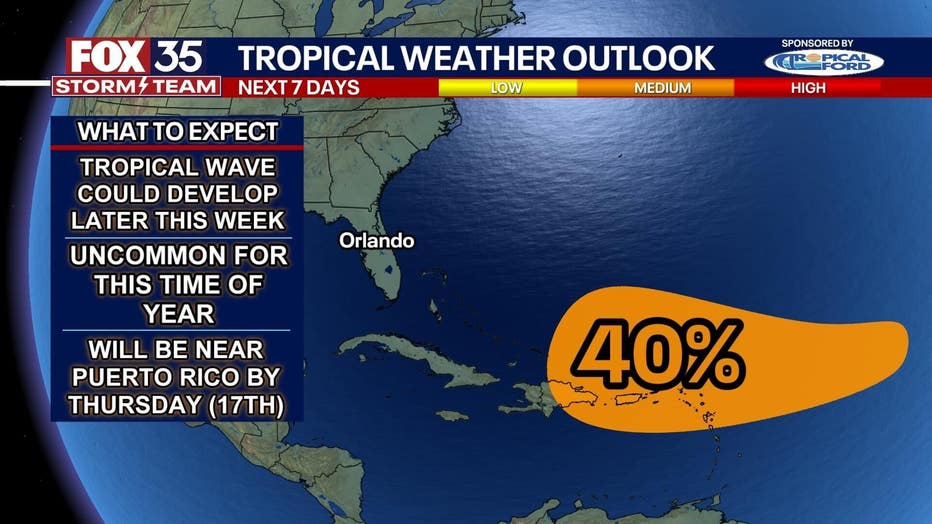
We are not out of the woods yet. Hurricane season lasts until November 30 so we still have some time before we are fully in the clear of Hurricane season.W ith that, here is what models are showing. As TJ said earlier, models are showing Invest 94L to move into the Caribbean Islands and develop in the more favorable environment. With the current pattern of the atmosphere, this cold front pushing in this week and the ridge of high pressure building in would steer anything that has the potential of forming in the Eastern Caribbean, back out into the Atlantic. This is seen in the ensembles and most models.