

TIMELINE: Storms to bring heavy rain, frequent lightning in Central Florida Saturday afternoon
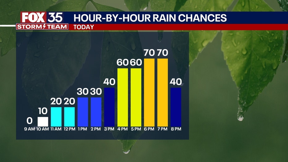
ORLANDO, Fla. - After a mostly dry start to our morning, showers and storms will once again return this afternoon across Central Florida. These will begin to form and move into the region as early as noon, with best chances of showers and storms starting at around 4pm.
By 8-9pm, things will begin to quiet down as rain gradually fades. Very heavy rain and frequent lightning will be associated with these storms, so make sure you're prepared if you have any outdoor plans!
These will be slow moving downpours as well, so some areas could pick up an additional 2-4" of rain on top of what has already fallen this past week.
TOMORROW: The second half of the weekend will feature more of the same when it comes to rain chances and hot temperatures. Scattered afternoon showers and storms are likely with more rounds of heavy rain on the way with highs near 90-degrees.
LOOKING AHEAD: The upcoming work week will still be plagued by a stalled front and a very warm and moisture-rich airmass. This means daily rounds of showers and storms are in store for much of this week, with heavy and flooding rain possible. With the amount of rain we've had this past week, there isn't much room left for more heavy rain to fall. With the amount of rain these showers and storms this week could produce, more flooding is possible. Stay weather aware and remember to never drive through flooded roadways!