

Orlando weather: Afternoon showers return on Monday across Central Florida
ORLANDO, Fla. - Monday will be a bit of a "rinse and repeat" of Sunday storms popping up in the late afternoon and lingering into the early evening.
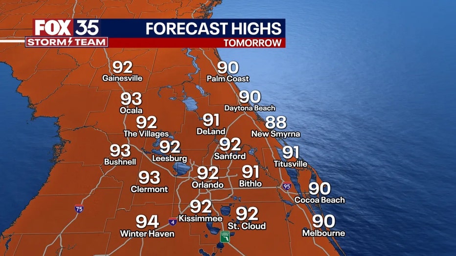
Highs will approach the mid-90s for inland areas and closer to the upper 80s and low 90s along the coast and beaches. The feel-like temperatures will be in the low 100s. Be sure to stay cool and hydrated if you plan to be outside! We'll stay mostly dry through midday, except for a few coastal downpours moving onshore.
As the Atlantic sea breeze moves inland, there is a much higher chance of rain this afternoon. Keep in mind that those who do see the rain can expect heavy downpours, frequent lightning, and wind gusts up to 40 mph.
LOOKING AHEAD: Hot temperatures with daily rounds of showers and storms will last through roughly the middle parts of this week. Slightly drier air will steadily filter in by Wednesday and Thursday, leading to lower chances of showers and storms but high temperatures closer to the mid-90s.
Tracking the Tropics
No tropical development is expected over the next seven days. However, we're keeping close tabs on a few tropical waves moving across the Atlantic.
The National Hurricane Center (NHC) is tracking three tropical waves – one off the Yucatán Peninsula, one in the eastern Caribbean Sea, and one off the coast of Africa in the Atlantic Ocean.

Orlando 7-Day Weather Forecast

Orlando Hour-by-Hour Weather Forecast

FOX 35 Storm Tracker Radar
Track live when storms move across your area using the FOX 35 Storm Storm Tracker Radar below.

More radar maps from FOX 35 Storm Tracker Radar
- Brevard County
- Flagler County
- Lake County
- Marion County
- Osceola County
- Orange County
- Polk County
- Seminole County
- Sumter County
- Volusia County
- U.S./National Radar
Stay connected with FOX 35
- Download the FOX 35 News app for the latest news, weather, and traffic alerts
- Download the FOX 35 Storm Team Weather app for live, interactive radar
- Visit FOX35Orlando.com/weather for interactive radar, plus updated weather graphics, maps, and images