

Invest 93L: Potential tropical threat to bring rain, thunderstorms to Florida on way toward Gulf

Tropics Update: July 14 Night
A disturbance in the Atlantic is expected to cross over Florida over the next day or two bringing with it heavy rains and the potential for some minor flooding. Once it reaches the Gulf, there is a chance that it could further develop into a potential tropical depression or tropical storm. FOX 35's Noah Bergren has the latest update.
ORLANDO, Fla. - The National Hurricane Center has declared an area of low pressure off Florida's east coast as Invest 93L, allowing computer models to run the potential tropical disturbance's path as it crosses over the Florida Peninsula this week.
Regardless, in Orlando and Central Florida, heavy rainfall, lightning, and some flooding are possible as this system moves across the state. Once it crosses the state and enters the Gulf, there is a chance that it could develop further, the NHC said.
CLICK TO DOWNLOAD THE FOX LOCAL APP
Tracking Invest 93L: Where is it? Where is it going?
The National Hurricane Center has now increased the chances for tropical development to 40% this week. The system—potentially to be named Dexter—could form in the Gulf and may become a significant rainmaker wherever it tracks.
The tropical wave will cross Central Florida on Tuesday, bringing widespread showers, thunderstorms, and the possibility of a brief tornado or two.
While development into a tropical depression before it reaches the Space Coast Tuesday morning is unlikely, it remains possible.
Forecasters advise residents, especially those in southern Louisiana and Mississippi, to monitor the system closely from Thursday through Saturday.
SIGN-UP FOR FOX 35'S BREAKING NEWS, DAILY NEWS NEWSLETTERS
Rainfall forecast: How much rain could Orlando, Central Florida get this week?
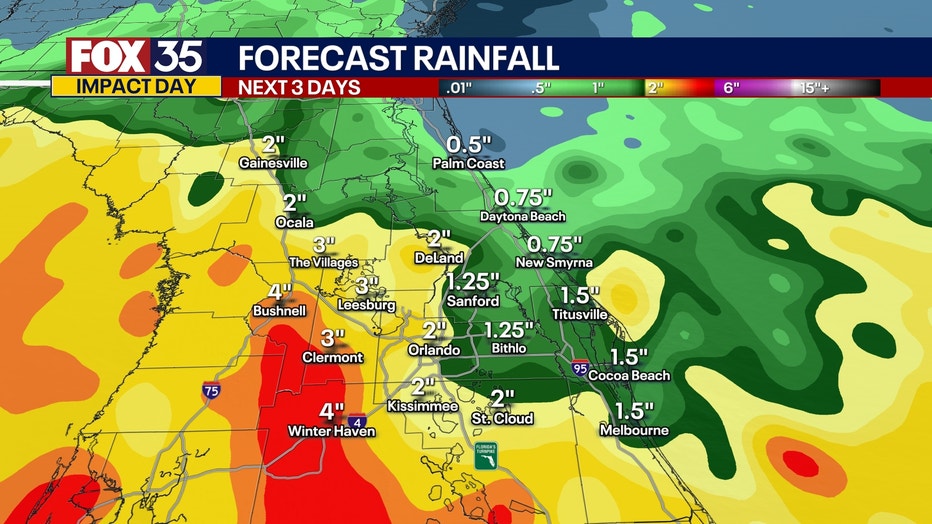
Rainfall totals vary throughout the state. It all depends on where the rainbands fall and how fast they move, according to FOX 35 meteorologist T.J. Springer.
Some areas could receive an inch of rain or less, while others could see upwards of 5" of rain.
Some spots west of Orlando, closer to the Gulf could pick up between 4-5" while areas in Volusia or Brevard County only see an inch or two.
Timeline: When does the rain arrive?
Monday Forecast
Through the remainder of the day, hit-or-miss showers and storms are on the table. A couple could turn severe with gusty winds near 60 mph being the primary hazard. There could be some small hail as well in the strongest of cores. There is a Marginal Risk of severe weather – or a 1/5 -- on the risk scale. Scattered showers and storms continue to move around the broader circulation offshore through the overnight. As the area of low pressure starts to move on shore into the wee hours of Tuesday, we'll likely start to see coverage pick up again.
Tuesday Forecast
Florida could see numerous scattered showers and thunderstorms on Tuesday throughout the day. This is because the area of low pressure offshore of the East Coast will be be gradually working to the west, toward the Gulf. Once again, a couple of these storms could be on the stronger side, producing gusty wind and torrential rain.
Wednesday Forecast
Wednesday does look slightly drier as the low pressure center will be emerging in the Gulf. Though, there will still be the potential for showers and thunderstorms as tropical moisture from the outer bands of Invest 93L circulate along the western coast. Timing for storms is most likely in the afternoon and evening.
What factors would allow this system to develop?
The warmer than normal water is going to be a driver in the potential development as this area of low pressure shifts into the Gulf. Water temps are in the middle to upper 80s with wind shear also minimal. There are some pockets of higher shear, beyond 25 mph or so which is less conducive for intensification, but there is a solid area in the heart of the Gulf with the help of this high pressure where shear is around 10-15 mph. That would make for strengthening. Most data doesn't show anything more than a depression if anything develops at all, but if this system can linger over the warmth...just like Chantal, we could see the chance of more strengthening.
The Source: The information in this forecast comes from the FOX 35 Storm Team, the National Hurricane Center, and the National Weather Service.