WATCH: Tropical Storm Eta brings strong winds, flooding to Florida
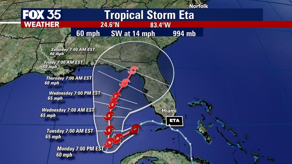
MIAMI - Tropical Storm Eta is located just off the coast of Florida and is expected to make landfall in the state but exactly where is hard to pinpoint, as the latest models show some uncertainty.
Eta hit land late Sunday on Lower Matecumbe Key, Florida. The system’s slow speed and heavy rains posed an enormous threat to South Florida, an area already drenched from more than 14 inches of rain last month. Eta could dump an additional 6 to 12 inches, forecasters said.
It is now moving up the Gulf of Mexico, targeting Florida's Big Bend region. If the current track holds, Eta will make landfall as a tropical storm on Saturday in the Panhandle.

As Tropical Storm Eta moves closer to the Panhandle, Central Florida has started to feel gusty winds, heavier rainfall, and rough storm surge.
FOX 35 is compiling videos of the storm's impact as it comes in.
Winds and storm surge pick up at Cocoa Beach as Tropical Storm Eta nears
FOX 35 reporter Jessica Albert took this video on Monday morning.
Heavy rainfall in New Smyrna Beach as Tropical Storm Eta nears
As Tropical Storm Eta moves closer to the Panhandle, Central Florida has started to feel gusty winds, heavier rainfall, and rough storm surge.
RELATED: Where will Eta make landfall? Florida feels tropical storm's impact
Meanwhile, South Florida felt the effects of the storm on Sunday and Monday, with strong winds, heavy rainfall, flooding, and rough storm surges moving into the area.
FOX 35 compiled videos from the region.
Storm surge on South Hutchison Island in Fort Pierce
FOX 35 viewer Ken Vathauer sent the video in on Monday morning.
Strong wind and rain hits Downtown Miami
Tropical Storm Eta brought strong winds and rain to Miami, Florida, in the late evening and early morning of Sunday and Monday. Video by David Sanhz via Storyful.
Tropical Storm Eta brings flash flooding to South Florida
Floods were seen inundating streets in Key Largo in the early hours of Sunday. Video by Mike's Weather Page via Storyful.
Apparent power outage caught on camera as Eta impacts South Florida
This video, which was recorded in Bay Harbor Islands in Miami Dade county, shows the moment power goes out. Video by lunaxai via Storyful.
Miami streets flooded as Tropical Storm Eta heads toward Florida
Six to nine inches of rain was forecast for south Florida through Tuesday, reports say. Video by Jackson Dill via Storyful.
Tropical Storm Eta whips up wild surf along Florida coast
As Tropical Storm Eta approached the Florida Keys on Sunday, large waves pounded the coastline. Video by Rick Lococo via Storyful.
WEATHER ALERTS: Download the FOX 35 Weather App to track the tropics on your phone, receive severe weather alerts, and get the latest daily forecasts
Out of an abundance of caution on Saturday, Governor Ron DeSantis issued an executive order declaring a state of emergency in the following counties: Broward, Collier, Hendry, Lee, Martin, Miami-Dade, Monroe, and Palm Beach Counties.
Brevard County prompted school officials to close all of the county's schools on Monday, as a tropical storm warning was active there. It has since expired. Nonetheless, the county could feel very strong winds and squalls. The situation is thankfully unfavorable for tornadoes but showers and thunderstorms could occur.
Tune in to FOX 35 Orlando for the latest tropics updates.

