Something may yet be brewing in the tropics: See 3 possible scenarios
With Hurricane Oscar officially fizzling as a tropical cyclone Tuesday, the Atlantic basin is now devoid of any tropical development, and the National Hurricane Center says no additional tropical development is expected within the next seven days.
Yet, don’t let your guard down on the tropics just yet, as signs are emerging that the break may be brief.
Currently, the atmospheric pattern has a lot of sinking air over the Caribbean and Gulf of Mexico, which inhibits tropical development. But the long-range prospects of the Madden-Julian oscillation — a global pattern that cycles areas of rising and sinking air every 30-90 days — suggests rising air will return to the Caribbean around the end of October and into early November.
That would coincide with the return of the Central American Gyre — which had a hand in creating Hurricanes Helene and Milton, and more recently, Tropical Storm Nadine.
WHAT IS THE CENTRAL AMERICAN GYRE?
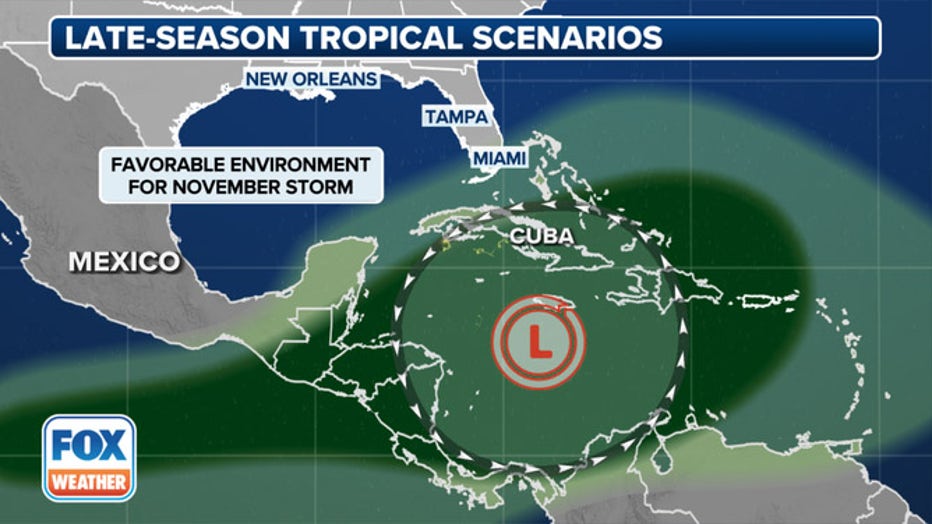
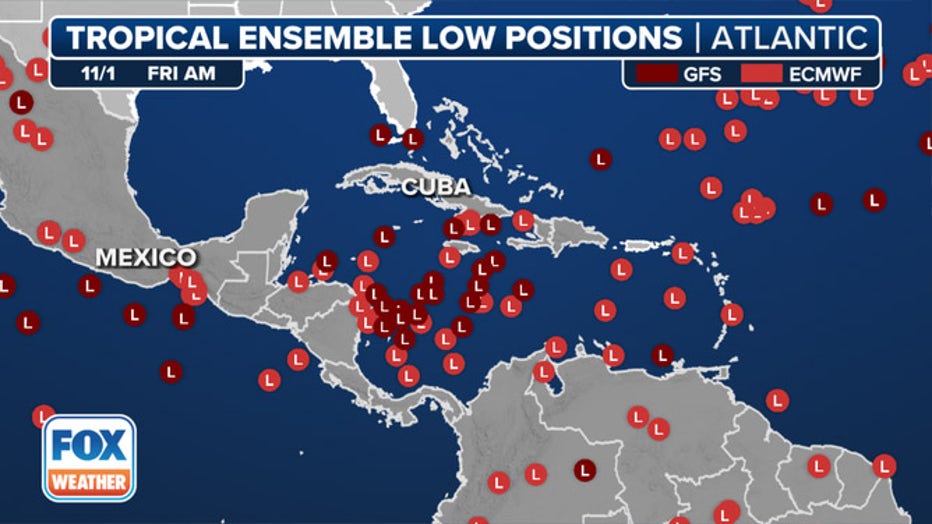
"At the very end of the month now, we get this low pressure that starts to form eerily similar to that Central America Gyre," says FOX Weather Meteorologist Steve Bender. "But this one is right over the heart of the Caribbean. So you've got all this tropical moisture that's going to be able to get tapped into."
(FOX Weather)
Those conditions would combine for favorable tropical development somewhere in the Caribbean, and if a storm were to form, it would have three main scenarios to follow depending on the surrounding atmospheric steering patterns that we would anticipate at this time of the year.
Most of the time, these cyclones aren’t a threat to the Lower 48, but occasionally, a storm system can come out of the deep tropics and impact Florida or provide a glancing blow to the Eastern Seaboard.
Tropical Formation Scenario 1: High pressure acts as a barricade for the US
(FOX Weather)
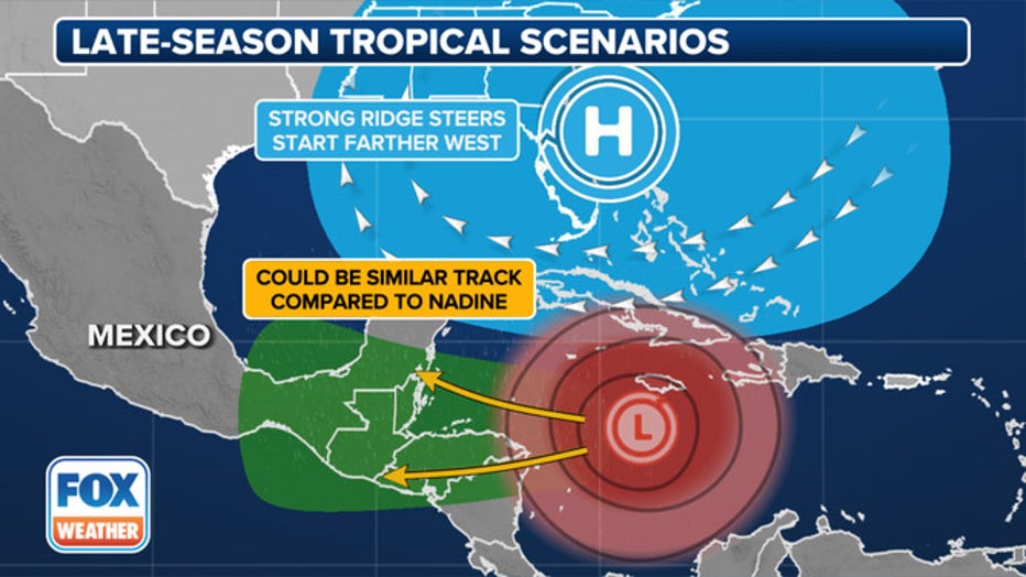
The first option would be for strong high pressure to remain anchored over the southeastern U.S., acting like a barricade that protects the American coasts.
That pattern would mimic what just happened with Tropical Storm Nadine and would steer any tropical cyclone west into Central America and perhaps back out into the Eastern Pacific.
Tropical Formation Scenario 2: Following in the footsteps of Oscar
(FOX Weather)
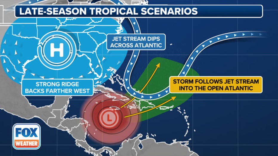
In this setup, the blocking ridge of high pressure would be centered farther west over the Deep South or Texas — still protecting the U.S. from any tropical storms, but allowing the jet stream to dip across the Atlantic.
This scenario would push tropical cyclones east across Cuba and the Greater Antilles, where it would eventually mimic Hurricane Oscar in interacting with the jet stream and becoming a post-tropical system as it gets pushed out into the open Atlantic.
Tropical Formation Scenario 3: US East Coast is more vulnerable
(FOX Weather)
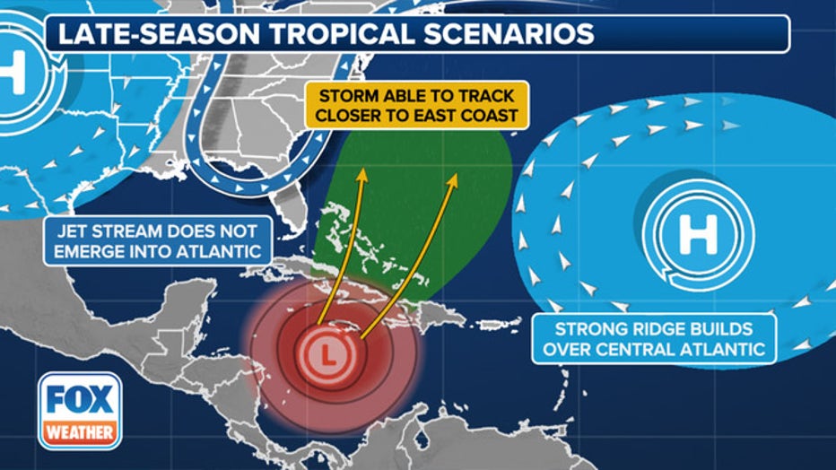
This scenario would be the most concerning for the U.S. In this case, a ridge forms too far west over the U.S. to provide much blocking, while a strong ridge of high pressure builds in the central Atlantic.
"You are looking at two high pressures that are kind of funneling (any storms) along the East Coast," Bender said. "And as it tracks, then you could start to see those impacts areas that have already felt massive impacts" from Hurricane Helene.
The long-range forecast models start to pick up on some signals for tropical development in the southern Caribbean around Oct. 29, with even more signals for development days later.
(FOX Weather)
"My concern would be the first day of November… we are well out (into the future)… and there’s going to be a large variability at this point," Bender said. "Climatologically speaking, that is the spot that we typically anticipate where you would see these form…. but there is a lot of potential activity ahead."
Gulf of Mexico waters finally cool off
There was some good tropical news to emerge this week in the Gulf of Mexico.
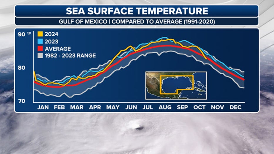
For the first time in more than a year, the average Gulf water temperature has dipped below average, thanks to a combination of cold fronts, persistent winds, and the churning effects of Hurricanes Milton and Helene.
(FOX Weather)
The last time temperatures were average was June 2023. However, they still currently average around 81 degrees overall - still plenty warm for tropical development.
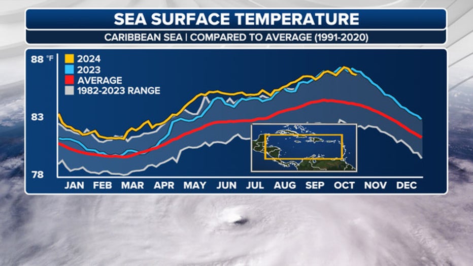
Water temperatures in the Caribbean remain at near record levels and well into the mid-80s.
(FOX Weather)
Hurricane season officially runs through Nov. 30
An average season tends to produce an additional two named storms during the final weeks of October and November, with one becoming a major hurricane.
LINK: GET MORE ON THIS STORY FROM FOXWEATHER.COM

