Tropical Storm Fred expected to weaken as it brings heavy rain to Georgia
Tracking the Tropics: Aug. 16, 2021
The FOX 35 Storm Team is monitoring three tropical systems. Fred was still a tropical storm late Monday but expected to weaken overnight. Tropical Depression Grace was bringing heavy rain to Haiti while Tropical Storm Henri remained relatively weak as it passed near Bermuda.
ORLANDO, Fla. - Tropical Depression Grace is drenching Haiti, dumping up to 15 inches of rain on a quake-damaged landscape as thousands of people huddle in fields and search for survivors.
Meanwhile, Tropical Storm Fred weakened after hitting Florida's Gulf Coast Monday afternoon near Cape San Blas. The U.S. National Hurricane Center said rainfall is the main threat from Fred and Grace. It's enough to close schools and government offices in Florida and Alabama, but such weather can cause devastating flash floods and mudslides in Haiti.
A third system strengthened into Tropical Storm Henri near Bermuda late Monday evening.
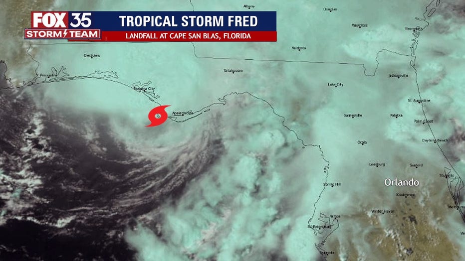
Fred came ashore at Cape San Blas at 3:15 p.m., about 25 miles west of Apalachicola. Maximum sustained winds were near 65 mph at landfall.

Tropical Storm Fred makes landfall in Florida Panhandle
Tropical Storm Fred made landfall in the Florida Panhandle on Monday afternoon.
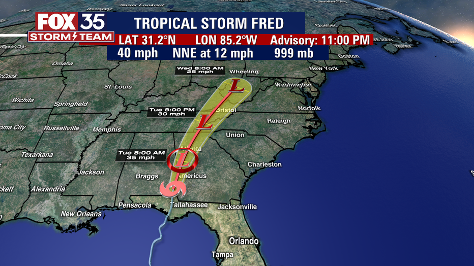
Fred remained a tropical storm as of 11 p.m. with its present movement north-northeast at 12 mph. The NHC anticipates further weakening of the storm.
The Tropical Storm Warning for the coast of the Florida Panhandlehas been discontinued. The Storm Surge Warning for the coast of the Florida Panhandle andFlorida Big Bend has been discontinued.

Maximum sustained winds had decreased to near 40 mph with higher gusts. Additional weakening is expected, and Fred should become a tropical depression overnight or early Tuesday.
On the forecast track, the center of Fred will move across western and northern Georgia on Tuesday, across the southern Appalachian Mountains on Tuesday night, and into the central Appalachians by early Wednesday.
Tropical-storm-force winds extend outward up to 45 miles (75 km)from the center. A wind gust of 53 mph was recently reported at the airport in Marianna, Florida.
TRACK THE TROPICS: Visit the FOX 35 Storm Team Hurricane Center for the latest tropical weather outlook and more
TROPICAL DEPRESSION GRACE

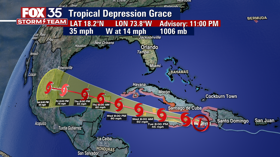
The NHC said that Grace remained a tropical depression just before 11 p.m. and was located about 100 miles west-southwest of Port-au-Prince, Haiti.
Forecasters said the depression is moving west-northwest at 14 mph and could bring flash flooding and mudslides to Hispaniola.
Grace reportedly has maximum sustained winds of 35 mph.
Some change in strength is expected over the next few days and it could become a tropical storm again by Tuesday.
On the forecast track, the center of Grace will continue to move near or over the Tiburon Peninsula of Haiti during the next couple of hours, and then move between southeastern Cuba and Jamaica on Tuesday. Grace is forecast to move near the Cayman Islands Tuesday night and then approach the Yucatan peninsula of Mexico late Wednesday or early Thursday.
Multiple watches and warnings are reportedly in effect:
- Tropical Storm Warning: Southern coast of the Cuban provinces of Santiago de Cuba, Granma, Las Tunas, and Camaguey and the Cayman Islands
- Tropical Storm Watch: Entire coast of Haiti, Jamaica, southern coast of the Cuban provinces of Ciego de Avila, Sancti Spiritus, Cienfuegos, and Matanzas, as well as Isla de la Juventud.
TROPICAL STORM HENRI

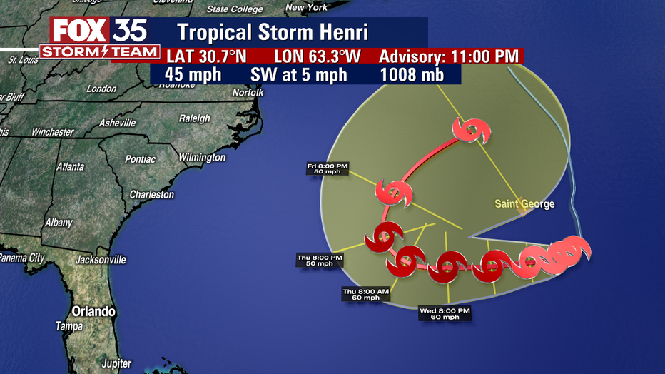
The NHC says Tropical Storm Henri was about 140 miles southeast of Bermuda late Monday.
Forecasters said that the system is moving south at 5 mph and is expected to stay at sea.
WEATHER ALERTS: Download the FOX 35 Storm Team Weather app for live radar, severe weather alerts, and daily forecast reports on your phone
It reportedly has maximum sustained winds of 45 mph.
A turn toward the west is forecast by Tuesday night, and a slightly faster westward motion should continue through early Thursday. On the forecast track, thecenter of Henri should pass well to the south of Bermuda lateTuesday afternoon or Tuesday night.
Henri is a small tropical storm. Tropical-storm-force winds only extend outward up to 35 miles from the center.
Watch FOX 35 Orlando for the latest from the Storm Team.

