2 systems brewing ahead of hurricane season, one could potentially become Ana
Weather Forecast: May 21, 2021
FOX 35 Storm Team Meteorologist Allison Gargaro has the latest on the weather in Central Florida.
ORLANDO, Fla. - The National Hurricane Center and the FOX 35 Storm Team are now watching two tropical disturbances – and hurricane season doesn't start until June 1.
The first is located over the western Gulf of Mexico. Conditions are marginally favorable for development. There is a 60% chance for formation within the next five days.
Regardless of development or not, this system could produce heavy rain over portions of southeastern Texas and southwestern Louisiana this weekend.
Due to strong high pressure and easterly winds, the track of this system has it moving north, staying pinned along the western Gulf of Mexico. You can track the latest tropical models and weather maps on OrlandoHurricane.com.
The FOX 35 Storm Team is also watching a non-tropical low-pressure system about 450 miles east-northeast of Bermuda and has become better organized. It currently has a 90% chance of developing over the next five days.
The low is expected to move westward over warmer waters Thursday night into Friday, and will likely become a subtropical cyclone near Bermuda.
However, the system is expected to move toward the north and northeast, away from the United States, into an unfavorable environment by late Sunday.
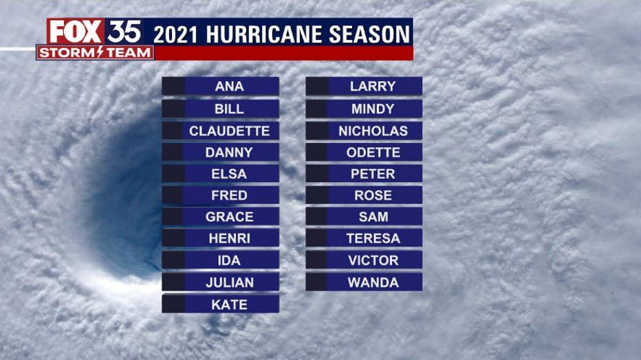
The system will generate long-period swells at area beaches by Sunday. If the system does become a named storm, it will be called ANA – our "A" storm kicking off the coming Hurricane Season which officially begins on June 1.
Winds will remain breezy, out of the east, so expect a moderate risk for rip currents this weekend.
Partly sunny and dry conditions persist into the weekend. Afternoon highs will be in the low 80s along the coast with mid to upper 80s across the interior.
Small craft advisory, rip current risks this weekend
FOX 35 Storm Team Chief Meteorologist Jayme King says strong, easterly winds present choppy conditions and has prompted a small craft advisory. In addition, there is a high risk for strong, life-threatening rip currents.
Get prepared: 2021 Atlantic hurricane season is quickly approaching
Regardless of development, land impact looks unlikely.
Overnight lows will be in the mid-to-upper 60s.
By Sunday, temperatures in Central Florida will hit 90 degrees, with the mid-80s along the coast.
High pressure will park itself on top of the area Monday, so expect temperatures to soar into the mid-and-upper 90s early next week.
WEATHER ALERTS: Download the FOX 35 Storm Team Weather app for live radar, severe weather alerts, and daily forecast reports on your phone

High pressure will park itself on top of the area Monday, so expect temperatures to soar into the mid-and-upper 90s early next week.
RELATED: NOAA predicts above-normal 2021 Atlantic hurricane season
On Thursday, the National Oceanic and Atmospheric Administration (NOAA) predicted an above-normal 2021 Atlantic hurricane season.
NOAA forecasters said that there is a 60% chance of an above-normal season, a 30% chance of a near-normal season, and a 10% chance of a below-normal season.
They said that they expect 13 to 20 named storms, which can pack winds 39 mph or higher. Six to ten of those could become hurricanes, with winds increasing to 74 mph or higher. Of those, three to five could be major hurricanes, reaching winds of 111 mph or higher (Category 3 storms and up).
Stay with the FOX 35 STORM TEAM for the very latest as we're always watching and always tracking.
Watch FOX 35 News for the latest weather updates.

