Is next named tropical storm in the Caribbean? NHC monitoring disturbance
A tropical disturbance expected to form in the Caribbean Sea in the coming days has a medium chance – 60% – of further development over the next week, according to the National Hurricane Center.
The odds of development have steadily been increasing over the last several days from 10% to 20% to 30% to 40%, 50%, and now, a 60% chance of possible development into a tropical depression as early as next week as the weather pattern moves toward the Gulf of Mexico.
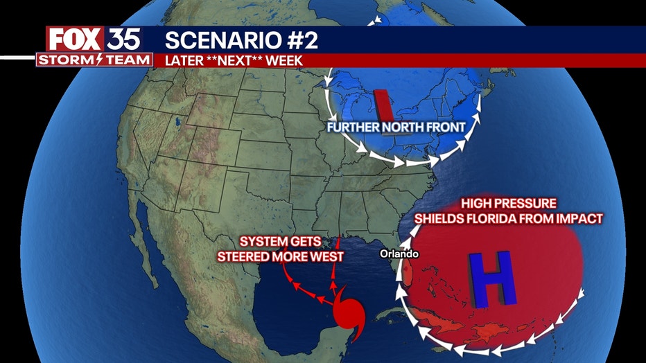
In its 8 p.m. advisory, the NHC said a broad area of low pressure could form early next week over the northwestern Caribbean Sea. As it intersects the warm ocean water, the potential system could develop into a tropical depression as it moves into the Gulf of Mexico by the end of the week.
Those along the Gulf of Mexico, including in Florida, are watching this potential system closely. It's too early to tell where it will ultimately go, however.
Will the tropical disturbance in the Caribbean impact Florida?
There is a possibility that the system could impact Florida, which is why officials are closely monitoring it. Once it develops, the NHC will have a better handle on where it is going to go from there.
"What we do know at this time is that the conditions are right in that zone for a tropical system to take off. The ocean temperatures are very warm and the low shear in that zone could lead to a homegrown tropical system in the Gulf, so we will be monitoring this closely. Ultimately, if a system does form, it could intensify very quickly," said FOX 35 meteorologist Laurel Blanchard.

The forecast models are not consistent in where it is predicting this potential system will go. Depending on shifts in the atmosphere, some models show the system impacting Mississippi, Alabama, Louisiana, Texas, and a little bit of Florida. Other models show a shift directly toward Florida.


If the system were to become the eighth named storm of the 2024 Atlantic hurricane season, it would be called Helene.
Could the remnants of Tropical Storm Gordon re-develop?
In its latest update, the National Hurricane Center said the remnants of Tropical Storm Gordon are less likely to reform into a tropical depression or tropical storm.
The chances were reduced from 30% to 10% on Friday afternoon.
Showers and thunderstorms have become more displaced and farther away from the center of the area of low pressure, the NHC said, due to strong upper-level winds.
"Significant development of this system is not expected while it meanders over the central subtropical Atlantic during the next couple of days," the NHC said.

Invest 96L: System brews in subtropical Atlantic Ocean
Another disturbance, known as Invest 96L, is located about 650 miles northeast of the northern Leeward Islands.
The National Hurricane Center said this system is producing disorganized showers and a few thunderstorms. However, chances for further development of this system remain low - 10%.
"Environmental conditions do not appear conducive for significant development of this system during the next couple of days while it drifts northwestward at about 5 mph over the central or western subtropical Atlantic," NHC.
Stay connected with FOX 35
- Download the FOX 35 News app for latest news, weather, and traffic alerts
- Download the FOX 35 Storm Team Weather app for live, interactive radar
- Visit FOX35Orlando.com/weather for interactive radar, plus updated weather graphics, maps, and images
Orlando 7-Day Weather Forecast
Orlando Hour-by-Hour Weather Forecast
FOX 35 Storm Tracker Radar
Track live when storms move across your area using the FOX 35 Storm Storm Tracker Radar below.
More radar maps from FOX 35 Storm Tracker Radar
- Brevard County
- Flagler County
- Lake County
- Marion County
- Osceola County
- Orange County
- Polk County
- Seminole County
- Sumter County
- Volusia County
- U.S./National Radar
STAY CONNECTED WITH FOX 35 ORLANDO:
- Download the FOX 35 News app for breaking news alerts, the latest news headlines
- Download the FOX 35 Storm Team Weather app for weather alerts & radar
- Sign up for FOX 35's daily newsletter for the latest morning headlines
- FOX Local: Stream FOX 35 newscasts, FOX 35 News+, Central Florida Eats on your smart TV


