

Invest 93L may loop back to Florida in rare appearance, raising flash flood risk

Tropics update: July 17, 2025
FOX 35 meteorologist Brooks Garner has the latest conditions in the tropics. The 2025 Atlantic Hurricane Season runs June 1 - November 30. Download the FOX Local app for tropical alerts and notifications.
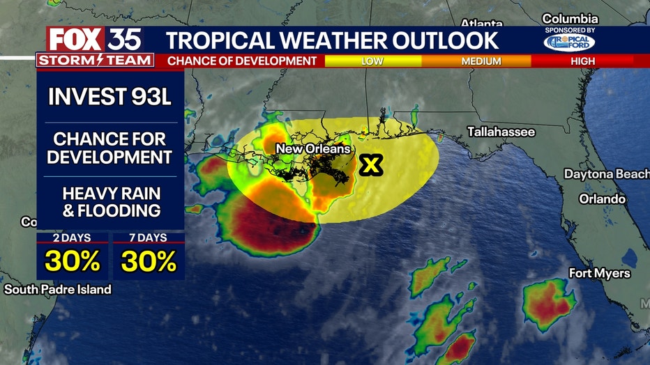
ORLANDO, Fla. - Our flash flooding threat may return next week from the same system that dumped 6-9" of rain across parts of our region earlier this week, resulting in spotty flash flooding.
The tropical low, known as, "Invest 93L", has since moved west into Louisiana and could unload over a foot of rain for Bayou County. Then once it moves northward, over land where it'll weaken, thing may get interesting.
Our major long-range computer weather models suggest as the circulation moves north, weakening over land, it'll get caught up in the larger flow and push back east toward the Atlantic. While the center of low pressure and counter-clockwise moving winds will become indiscernible compared to surrounding prevailing winds, its core of deep tropical moisture will remain intact and trackable... and that track looks to loop all the way back to Florida by early next week!
While it won't be called, "Invest 93L" when it returns (since it will have lost its circulation and low pressure center), it will be easy to spot due to its core of dense evaporated water vapor held aloft. As it moves back into our region early next week, it'll act like fuel for heavy thunderstorms.
CLICK TO DOWNLOAD THE FOX LOCAL APP
This means when it interacts with our late-July daytime heat, storm chances will not only increase, but they'll be capable of producing heavy rain and localized flash flooding, especially where soils are already saturated.What makes this pattern even more interesting -- if that's not enough -- is what could happen once the system dips back over the Gulf next week.
The warm waters and favorable conditions might give it a second chance at organizing, and while that’s far from guaranteed, it's something we'll will be keeping a close eye on.
Even without formal development, its moisture signature will remain important. In fact, some longer-range models go a step further and suggest this system’s traceable moisture could perform yet another loop—a third—by the end of July, potentially swinging around again to bring even more rain to parts of the Southeast.
These looping paths are rare but not unheard of, and this one is starting to resemble an atmospheric boomerang .Whether or not this system spins up again or triggers widespread flooding, it’s clear that we’re heading into a stretch of wetter-than-normal weather.
SIGN-UP FOR FOX 35'S BREAKING NEWS, DAILY NEWS NEWSLETTERS
Rain chances will run higher than what’s typical even for late July, which is already a wet time of year. While not every location will see flooding, the repeated rounds of showers and storms will likely be enough to wipe out any lingering pockets of drought in the region. This unusual setup is a good reminder that even when a tropical wave seems to fade from the radar, its moisture can still have a powerful and prolonged impact.
The Source: This story was written based on information shared by FOx 35 Storm Team Meteorlogist Brooks Garner, as well as the National Centers for Environmental Prediction, the European Centre for Medium-Range Weather Forecasts and the Canadian Meteorological Centre