

Orlando weather: Warm temps, rain chances and high rip current risk at local beaches this Labor Day weekend

Labor Day weekend: How will the weather be?
Rip current risk will be sky high for the Labor Day Holiday weekend as ocean breezes ignite and ocean swell from distant Idalia focus on our local surf zones.
ORLANDO, Fla. - Today's high: 90 degrees | Tonight's low: 76 degrees
Main weather concerns: Friday weather in Central Florida remains quite warm & muggy as highs climb to near 90 for inland locations, mid-80s along the beaches. Rain chances are possible during the morning but, the real increase comes after roughly 2pm this afternoon.
Rain chances hold steady this evening with many areas picking up a scattering of showers and storms.
Winds will freshen a bit today from the Northeast and this trend will continue through the weekend. Rip current risk will be sky high for the Labor Day Holiday weekend as ocean breezes ignite and ocean swell from distant IDALIA focus on our local surf zones.
BEACHES: The beaches see mixed skies and rain chances staging before 12pm, increasing in coverage after 12pm. Chances are near 60% this afternoon. Rip current risk is high as onshore winds combine with increasing swell from distant IDALIA.
Beach visitors should be mindful that the rip risk will be in play through the Labor Day Holiday weekend at all local beach fronts.
THEME PARKS: Another hot and humid afternoon with temps climbing well into the 90 degree range/heat index near 106 degrees this afternoon.
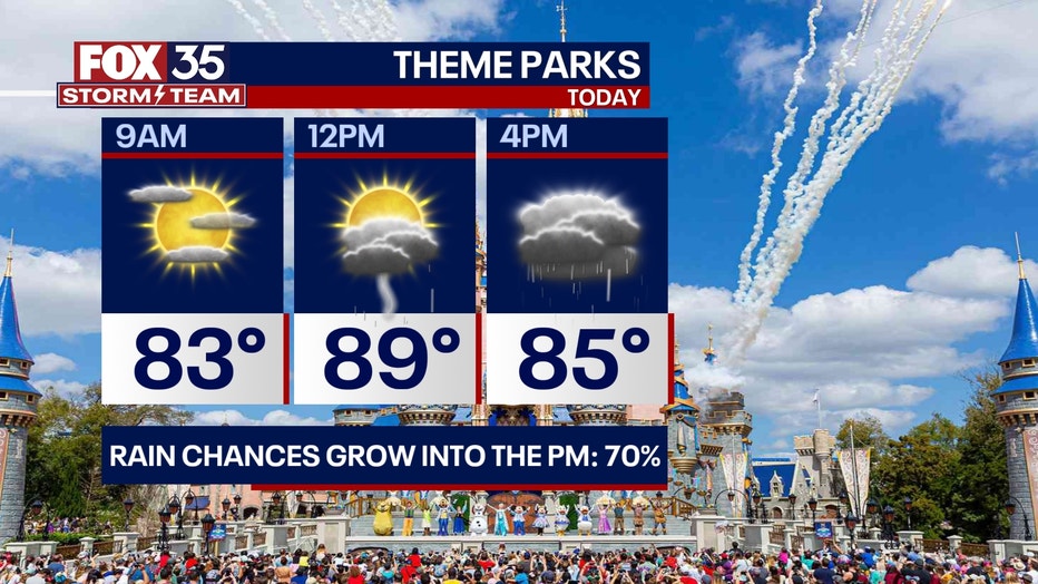
Showers and storms are possible before 11am with coverage increasing to 60-70% this afternoon. Heavy rain and lightning strikes will be of issue in any stronger storms.
OUTLOOK: Dry air will move in by the Labor Day Holiday weekend. Rain chances during this time head for the 20% range in all locations. Highs remain around the upper 80s to around 90, lows in the low-mid 70s.
Rip currents will be of issue along the Atlantic beaches as swell from Tropical Storm Idalia as that storm courses through the Atlantic this weekend. An increase in local winds from the Northeast this weekend adding wind waves into the mix. The combo of all of the above will keep rip current risk very high.
TRACKING THE TROPICS: The tropical outlook is very busy at this time. While IDALIA is currently "post-tropical", the center of the system could reform back into tropical storm status at some point on this Friday. Idalia could threaten Bermuda over the weekend.

Multiple tropical systems being watched
The FOX 35 Storm Team is tracking several systems in the tropics.
Hurricane Franklin will continue moving out the sea and away from any land. Tropical storm Jose continues moving North over the open Atlantic and away from land. The remains of Gert could reform just South of Jose, that will stay out at sea as well.
Invest area "AL-94" located just West of Africa will move Northwest over the Eastern Tropical Atlantic. Development of this feature is quite high. Lastly, another tropical wave moving WNW over the Eastern Tropical Atlantic has a 40% of developing over the next 7 days, something the FOX 35 STORM TEAM is watching.