

Orlando weather: Timeline of storms expected this evening for parts of Central Florida
Orlando Weather: Strong storms expected Tuesday evening
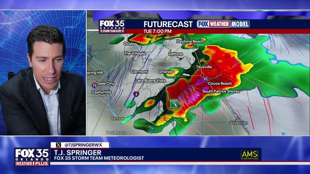
Numerous showers and thunderstorms are expected to develop this evening, with the greatest coverage occurring between 6 p.m. and 11 p.m.
ORLANDO, Fla. - Numerous showers and thunderstorms are expected to develop this evening, with the greatest coverage occurring between 6 p.m. and 11 p.m.

This will be a late-day sea breeze-driven storm event, bringing widespread rain and the potential for a few strong-to-severe storms.
When and where storms will develop
What To Expect:
Storms and heavy downpours will move southward from North Central Florida, with isolated flash flooding, hail and damaging wind gusts possible.

Torrential rain and large hail represent the greatest risks, but gust could reach or exceed 60 mph in some places.

Scattered showers and non-severe thunderstorms may linger after midnight, but the threat of strong to severe weather is expected to remain confined to the evening hours.
CLICK TO DOWNLOAD THE FOX LOCAL APP
Storms will generally move south-east along a line from Gainesville and Ocala to Melbourne, and a few could pack a punch.

The greatest risk for stronger storms looks to be north of the Orlando metropolitan area, where lightning, gusty winds, hail, and even a brief isolated tornado can’t be ruled out.

Wednesday forecast for Orlando
What To Expect:
A cold front will sweep south across the region during the morning and midday hours of Wednesday.
Expect mostly cloudy skies with a few early morning sprinkles and showers, with conditions drying out by afternoon as drier air arrives. Winds will become increasingly gusty, especially during the afternoon and evening, with north-east winds of 20 to 30 mph.
Also, temperatures will be cooler, with highs mainly in the low to mid 80s.
SIGN-UP FOR FOX 35'S BREAKING NEWS, DAILY NEWS NEWSLETTERS
This cooler air will remain through Thursday and Friday, thanks to a busy northeast flow. That breeze will help pull in drier air and knock rain chances way down, likely near zero by Friday and Saturday.
The heat and more typical afternoon storm chances return early next week.
Cooler temperatures on the way
Looking Ahead:
A significant drop in humidity is expected from Thursday through Saturday behind this unusually strong June cold front. Rain chances will fall below 10% each day, with mostly sunny, dry conditions and a persistent breeze through the period.
By Sunday, heat and humidity will begin to return. High temperatures will climb back into the lower 90s, and daily afternoon shower and thunderstorm chances are expected to resume next week.
Tracking the tropics
No areas are currently being monitored for tropical development during the next seven days.
A non-tropical storm is expected to develop between Bermuda and the Carolinas on Thursday. That system will help increase winds and surf along East Coast beaches later this week.
Meanwhile, a low chance remains for an area of low pressure to develop in the central Gulf later this week. The system could briefly acquire some tropical characteristics while producing heavy rain, abundant moisture and gusty winds. Current projections suggest it would move northward toward Louisiana, Mississippi and Alabama by the weekend.
The Source: The information in this story was provided by the FOX 35 Storm Team.