

Orlando weather: Warm and muggy start to weekend with drier, cooler air on the way

Orlando Weather Forecast: Sept. 29, 2023
Central Florida could see another rainy evening before cooler, drier air approaches the region late this weekend.
ORLANDO, Fla. - Tonight's low: 74 degrees | Tomorrow's high: 88 degrees
Main weather concerns:
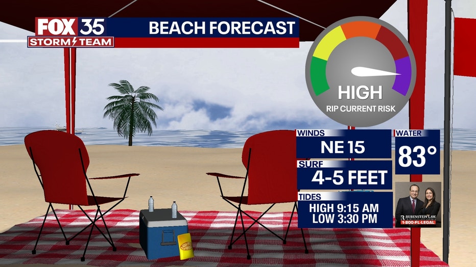
Central Florida's weather continues to be warm and muggy, but drier air is on the way. The same front that has produced all of this rain will sag southward toward Osceola and Brevard counties on Friday, focusing evening rain and storm chances across areas from Kissimmee to Palm Bay and the U.S. Highway 192 corridor. Be careful at the beaches this weekend and only swim near a lifeguard. Rip currents will be plentiful and with a lower-staffed lifeguard core this time of year, it could prove quite dangerous. Also, tides will be higher than normal thanks to the moon phase and the time of year, so water could reach the dunes or seawall at times of high tide. Consider this when venturing to a drive-on beach and check the tide schedules.
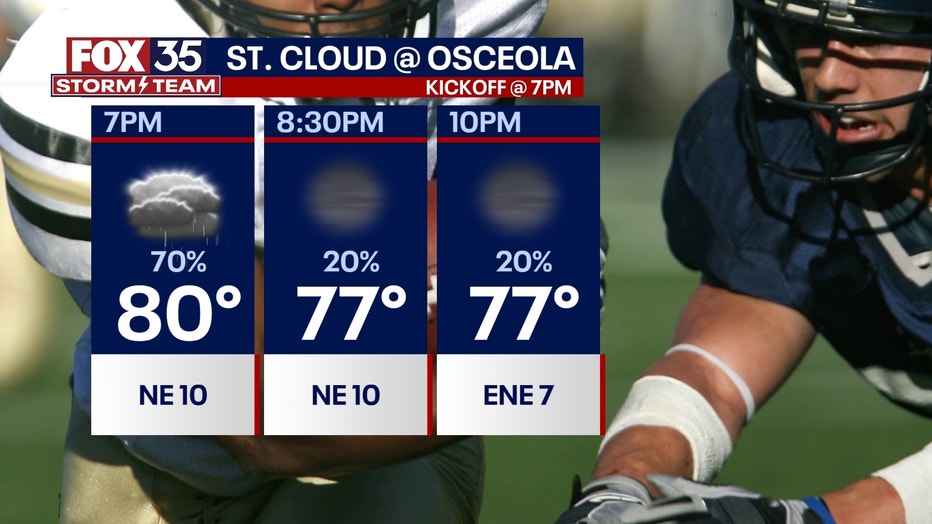
FOX 35 Game of the Week
Shower and storm chances remain high around kick-off at 7 p.m. Rain chances ease by halftime and hold steady at 20% or so through 10 p.m.
BEACHES:
Rain chances extend into Saturday. Heavy rain and lightning will be the main issues in any stronger storms. Rip current risk is high. Surf rolls in at two to four-plus inches with a mix of ENE swell in the water through the day. Tides are high at 9 a.m., and low at 3 p.m.
This time of year for King Tides. During this time, moon-influenced high tides can result in coastal flooding The full moon occurs today and that means tides will be quite high. A coastal flood advisory is in effect from Volusia County and Flagler County, through far Northern Florida for the possibility of coastal flooding in prone spots. During high tide cycles, local docks can see water creeping in on top, something to consider if you live in the coastal counties.
THEME PARKS:
Mixed skies and warm, muggy conditions at the attractions on Saturday. High near 87, rain chances reach a peak of 60% after 2 p.m. this afternoon but, don't rule out any showers before this time.
OUTLOOK:
Tropical moisture dominates for the weekend, scattered showers and storms look likely for both Saturday and Sunday afternoon. By Sunday, this front will push all the way into south Florida and allow drier air to move in, ending the constant threat of tropical downpours, and allowing for a pleasant first week of October with only a few coastal showers possible each afternoon next week.
Skies hopefully start drying out late this coming weekend through early next week. Depend on the FOX 35 Storm Team and download our Storm Team weather app to use the interactive radar feature.
TRACKING THE TROPICS
We're currently tracking tropical storms Philippe and Rina out of the distant Central Tropical Atlantic. Both of these systems will feature fluctuations in intensity, all while staying away from land long term. The FOX 35 STORM TEAM is tracking the tropics and will continue updating you on the latest!