

Orlando weather: Heat continues across Central Florida as dry air settles over region

Orlando Weather Forecast: June 29, 2023
Orlando and Central Florida will begin to see a shift in the weather pattern over the weekend with best chance for rain arriving around the Fourth of July.
ORLANDO, Fla. - Tonight's low: 75 degrees | Today's high: 95 degrees
Main weather concerns: Drier air has moved over the region allowing for lower rain chances for all locations. Heat continues to be the big weather story throughout the week as high pressure builds out of the Gulf South and smothers Florida. Highs remain around 95 inland, a touch cooler along the beaches where highs hang out in the upper 80s to around 90. The rain will return early next week.
BEACHES: The beaches remain a good option this Friday. Expect highs there around 90 degrees, rain chances are out of the picture.
Sunscreen and hydration will be necessary out there today. Rip current risk stands at moderate with a small long-period swell coursing into the local surf zone-this means surf heights in the 1' range.
THEME PARKS: Rain chances will be lower today with only a very isolated storm possible this afternoon after 3 p.m. Any storm could still produce heavy rain and lightning so be ready to head indoors. It will be toasty with highs in the mid-90s and lots of sunshine otherwise-generally dry conditions.
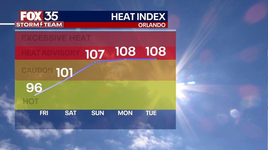
OUTLOOK: Looking into the quickly approaching Holiday weekend, hot temps dominate, rain chances slowly increase. Expect a continuation of highs in the mid-upper 90s, cooler along the beaches. Rain chances increase by Sunday to around 40% with a sharper rise as we draw closer to the July 4th Holiday on Tuesday. Eventually the arrival of tropical moisture from the Northwest Caribbean force coverage up to 60%+. Heavy rain could be a topic of discussion during this time.
TRACKING THE TROPICS: Tropical storm formation looks low through the next 7 days. NHC is watching a weak area of low pressure about 400 miles South-Southeast of Bermuda.
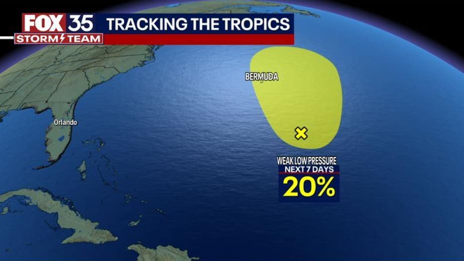
The chance of development for this feature stands at 20% over the next seven days.