

Potential Tropical Cyclone Six forms in Gulf of Mexico, expected to become tropical depression
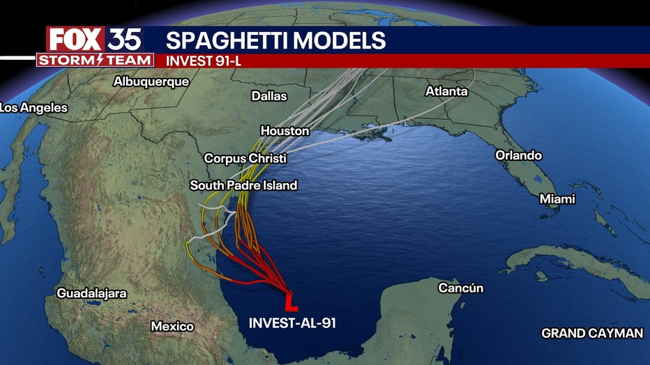
ORLANDO, Fla. - Potential Tropical Cyclone Six formed in the Gulf of Mexico late Sunday afternoon, the National Hurricane Center (NHC) said.
At the time of formation, the disturbance was located about 575 miles south-southeast of Port Arthur, Texas and moving northwest at about 5 mph.
What's next for Potential Tropical Cyclone Six?
The NHC said precipitation and thunderstorm activity have continued to increase, and Potential Tropical Cyclone Six is likely to form into a tropical depression within the next few days as the system moves to the northwest and then north near or along the Gulf Coast of Mexico and Texas through the middle of the week ahead.
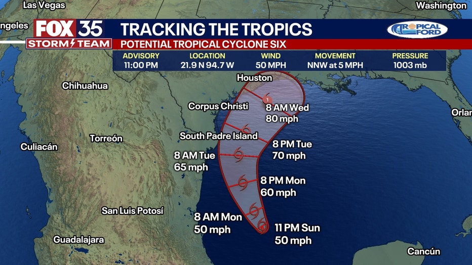
"A slow northwestward motion followed by a turn northward is expected over the next day or two," the NHC said. "The system is forecast to approach the northern Gulf Coast of Mexico on Tuesday and near the Upper Texas and Louisiana coastlines on Wednesday."
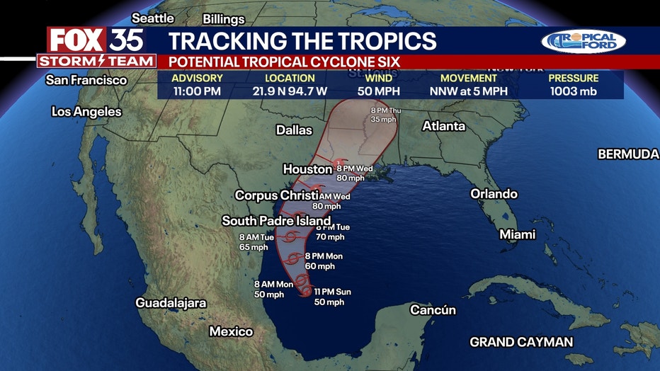
Maximum sustained winds are estimated at 50 mph with higher gusts, and tropical-storm-force winds extend outward up to 185 miles, mainly west of the center.
The system is expected to become a tropical storm on Monday, with more significant intensification forecast for Tuesday. It is predicted to reach hurricane status before approaching the northwestern U.S. Gulf Coast with the chance of formation at 90%.
"A slow northwestward motion followed by a turn northward is expected over the next day or two," the NHC said. "The system is forecast to approach the northern Gulf Coast of Mexico on Tuesday and near the Upper Texas and Louisiana coastlines on Wednesday."
Maximum sustained winds are estimated at 50 mph with higher gusts, and tropical-storm-force winds extend outward up to 185 miles, mainly west of the center.
The system is expected to become a tropical storm on Monday, with more significant intensification forecast for Tuesday. It is predicted to reach hurricane status before approaching the northwestern U.S. Gulf Coast with the chance of formation at 90%.

A Tropical Storm Watch is in effect for Barra del Tordo northward to the Mouth of the Rio Grande. Tropical storm conditions are possible within the watch area along the northern coast of Mexico starting Tuesday.
Potential Tropical Cyclone Six is expected to bring total rainfall of 4 to 8 inches, with isolated amounts up to 12 inches, from far northeast Mexico northward along portions of the Texas coast and into Louisiana through Thursday. This rainfall could result in flash and urban flooding.
Invest 92L slowly gaining traction in Central Atlantic
A trough of low pressure barely clinging to tropical relevance in the Central Atlantic has perked back up again, at least according to the long-range development odds given by the NHC.
The NHC said showers and thunderstorms associated with Invest 92L over the central tropical Atlantic continue to show signs of gradual organization.
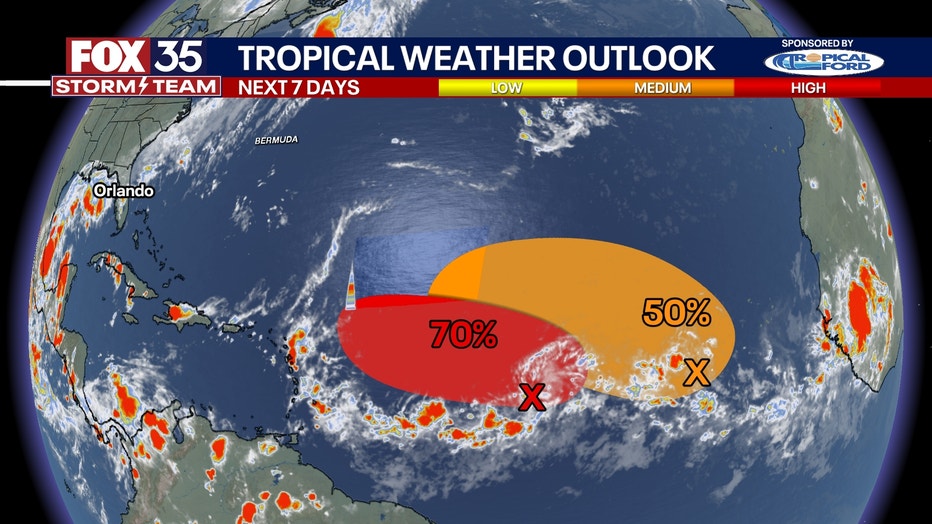
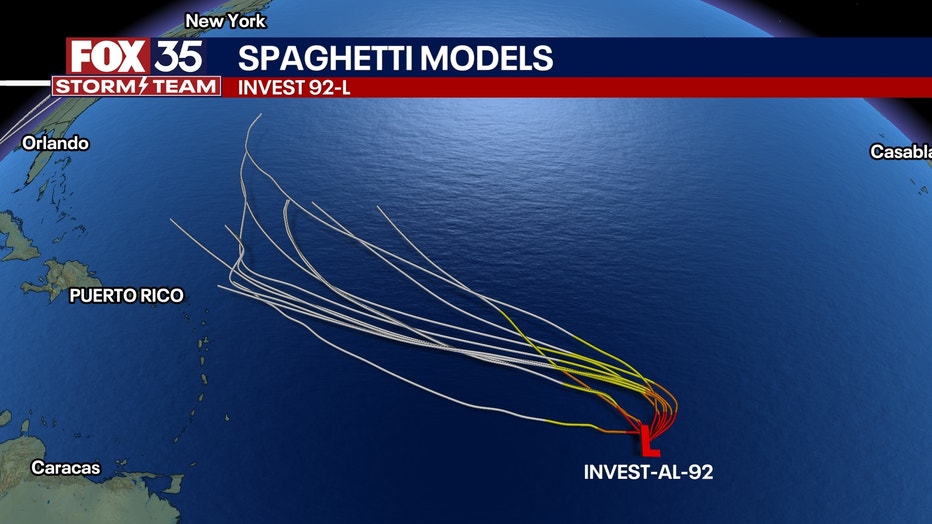
Environmental conditions appear conducive for additional development of Invest 92L, and a tropical depression could form. At the same time, the system spins over the central Atlantic through the beginning of the new workweek and then generally moves west through the rest of the week.
The NHC is giving Invest 92L a medium chance of developing.
Third area to watch in Eastern Atlantic
A third area to watch is now posted in the eastern Atlantic with a trough of low pressure located several hundred miles east-southeast of the Cabo Verde Islands, the NHC said.
According to the NHC, this tropical disturbance is expected to move very little over the next few days until it potentially interacts with a tropical disturbance that is forecast to move off the western coast of Africa early this week.
Environmental conditions are expected to be favorable for further development, and a tropical depression could form in the middle or latter part of the week.
The NHC is giving this tropical disturbance a medium chance of developing over the next week.
Orlando 7-Day Weather Forecast

Orlando Hour-by-Hour Weather Forecast

FOX 35 Storm Tracker Radar
Track live when storms move across your area using the FOX 35 Storm Storm Tracker Radar below.

More radar maps from FOX 35 Storm Tracker Radar
- Brevard County
- Flagler County
- Lake County
- Marion County
- Osceola County
- Orange County
- Polk County
- Seminole County
- Sumter County
- Volusia County
- U.S./National Radar
STAY CONNECTED WITH FOX 35 ORLANDO:
- Download the FOX 35 News app for breaking news alerts, the latest news headlines
- Download the FOX 35 Storm Team Weather app for weather alerts & radar
- Sign up for FOX 35's daily newsletter for the latest morning headlines
- FOX Local: Stream FOX 35 newscasts, FOX 35 News+, Central Florida Eats on your smart TV