Tropical Storm Julia forms in the Atlantic, expected to become hurricane this weekend
Tropical Storm Julia forms in the Atlantic, expected to become hurricane this weekend
FOX 35 Storm Team Meteorologist Ian Cassette has the forecast.
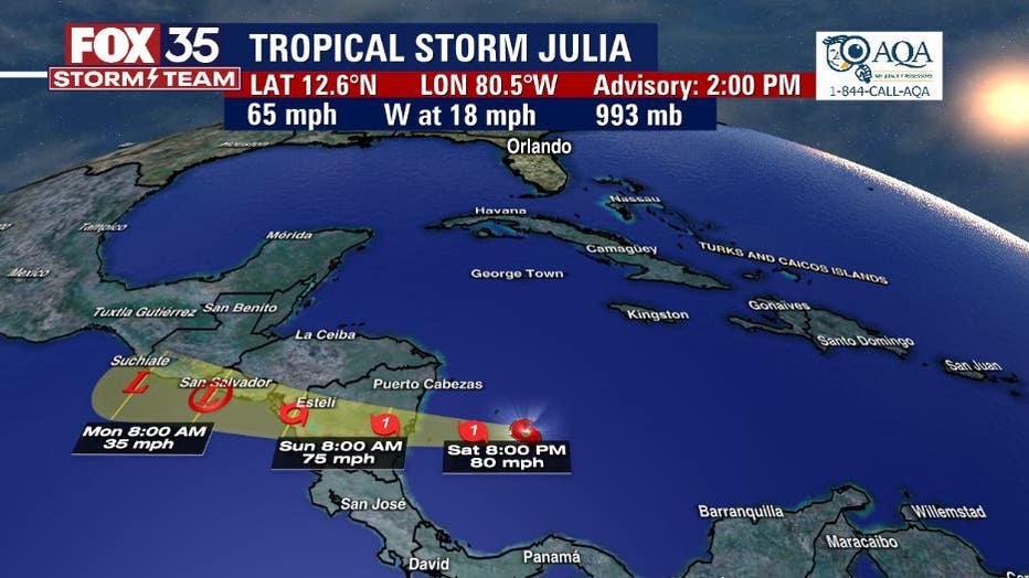
ORLANDO, Fla. - Tropical Storm Julia has grown a bit stronger and is expected to become a Category 1 hurricane on Saturday.
On Saturday, Julia was located east of Isla de Providencia Columbia with maximum sustained winds of 65 mph. Julia is moving toward the west near 18 mph.
Steady to rapid strengthening is forecast while Julia moves across the southwestern Caribbean Sea today and tonight, and the system is expected to become a hurricane later on Saturday.

"It is still a tropical storm, but expected to become a hurricane later today," said FOX 35 Storm Team Meteorologist Ian Cassette. "Julia will likely make landfall as a hurricane early Sunday morning and could bring flash flooding and mudslides over Central America."
MORE NEWS: Shocking photos from space show Florida 'shedding' water from Hurricane Ian
Weakening is forecast after the center moves inland over Nicaragua on Sunday, but Julia could still be at or near tropical storm strength when it moves near or along the Pacific coasts of Nicaragua, Honduras, and El Salvador Sunday night and Monday. Julia is forecast to become a remnant low by late Monday and dissipate by Tuesday.
A Hurricane Warning is in effect for:
- San Andres, Providencia, and Santa Catalina Islands Colombia
- Nicaragua from Bluefields to Puerto Cabezas
A Hurricane Watch is in effect for:
- Nicaragua north of Puerto Cabezas to the Honduras/Nicaragua border
A Tropical Storm Warning is in effect for:
- Nicaragua south of Bluefields to the Nicaragua/Costa Rica border
- Nicaragua north of Puerto Cabezas to the Honduras/Nicaragua border
- Pacific coast of Nicaragua
- Pacific coast of Honduras
A Tropical Storm Watch is in effect for:
- Honduras from the Nicaragua/Honduras border to Punta Patuca
- Coast of El Salvador
The system is not expected to be any threat to Florida or the rest of the United States.
So far, the 2022 Atlantic hurricane center has produced nine named storms: Alex, Bonnie, Colin, Danielle, Earl, Fiona, Gaston, Hermine, and Ian. The next two names on the list are Julia and Karl. October ranks as the third-most-active month (behind September and August) for tropical activity in the Atlantic Basin, typically producing about two named storms, one of which becomes a hurricane. And every other October, on average, one of those hurricanes intensifies into a "major hurricane," achieving Category 3 or higher intensity on the Saffir-Simpson Hurricane Wind Scale.
NOAA predicts an above normal hurricane season, calling for 14-20 named storms (winds of 39 mph or greater), of which 6-10 could become hurricanes (winds of 74 mph or greater). Of those, 3-5 could become major hurricanes (winds of 111 mph or greater).
Hurricane season ends November 30.

