

Timeline: Storms, flooding possible in Orlando as tropical disturbance moves across Florida
Tropical Update: July 14, 2025
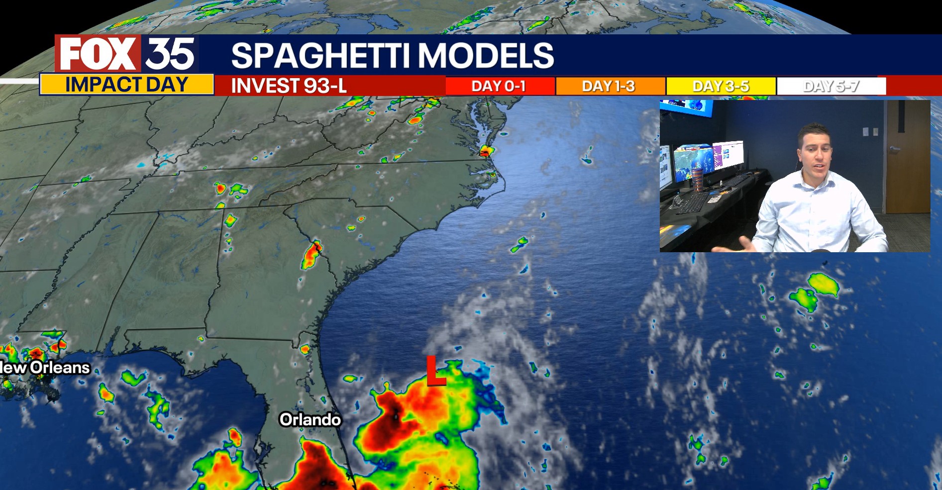
2:00 PM UPDATE: Meteorologist T.J. Springer has the latest on the tropics with newly formed Invest 93-L. Hurricane Season runs now through November 30th. Be sure to download FOX Local for all of the latest.
ORLANDO, Fla. - This story is no longer being updated. Click here to read our latest forecast on Invest 93L.
Central Florida is bracing for the potential of heavy rainfall and localized flooding this week as a tropical disturbance in the Atlantic moves westward toward the Gulf.
How much rain could fall in Central Florida?
What we know:
Forecasters say rainfall totals could vary widely across the region.
Areas west of Orlando, particularly those closer to the Gulf Coast, could receive 4 to 5 inches of rain.
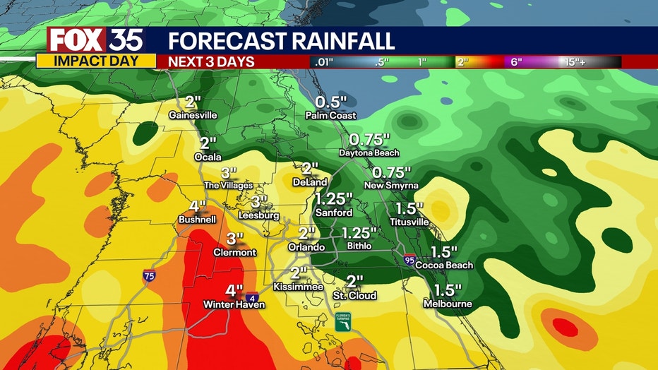
Coastal areas such as Volusia and Brevard counties may only see 1 to 2 inches.
The entire viewing area is under a slight risk for flash flooding, according to the FOX 35 Storm Team Meteorologists.
What is causing the stormy weather? Hello, Invest 93-L!
What we know:
We now have Invest 93-L in the South West Atlantic, which means the National Hurricane Center (NHC) is investigating this area of stronger storms and heavy rain.
It also means that we can now run all the assorted tropical modeling on this system as well as get support from the Hurricane Hunters.
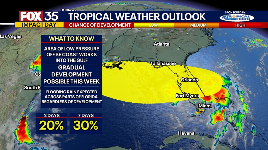
The National Hurricane Center has also now upped the chances of development to 20% over the next 2 days with a 30% chance of formation through the next week.
Here’s a breakdown of the current factors influencing the potential tropical development and expected weather across Florida:
- Warm sea surface temperatures (mid to upper 80s) in the Gulf could support storm development.
- Low wind shear in some areas (10–15 mph) may allow for storm strengthening.
- Higher shear pockets (above 25 mph) exist and could limit development in some regions.
- A high-pressure system is helping to create favorable conditions in parts of the Gulf.
Regardless of development, deep tropical moisture will bring heavy downpours and storms across Florida through midweek. Rain will be intermittent, but significant rainfall is expected.
RELATED ARTICLE: Invest 93L: Potential tropical threat to bring rain, thunderstorms to Florida on way toward Gulf
What we don't know:
The strengthening and how quickly is the most uncertain aspect of this system...at least at the moment.
There are some outliers in the data that suggest a stronger system moving into the Gulf and then strengthening potentially into Tropical Storm Dexter through the remainder of the week.
Most data doesn't show anything more than a depression forming, if anything develops at all.
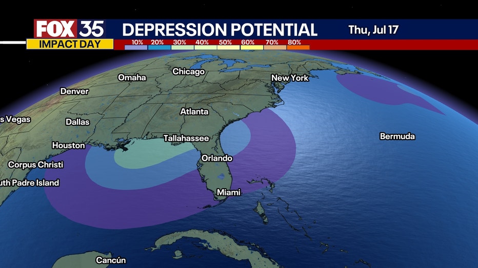
But what is for certain, if this system can linger over the warmth in the Gulf...just like Chantal did in the Atlantic, we could see the chance of more strengthening. It's something we're going to be monitoring closely.
Now that we have some stronger storms in the Atlantic, we could see at least a slim chance of even a depression before our Monday winds to a close or as early as Tuesday morning. Stay tuned!
Timeline: When will the rain arrive?
MONDAY:
Through the remainder of the day, hit-or-miss showers and storms are on the table. A couple could turn severe with gusty winds near 60 mph being the primary hazard. There could be some small hail as well in the strongest of cores.
There is a Marginal Risk of severe weather or a 1/5 on the risk scale. Scattered showers and storms are expected to continue to move around the broader circulation offshore through the night. As the area of low pressure starts to move on shore into the wee hours of Tuesday, we'll likely start to see coverage pick up again.
TUESDAY:
Numerous showers and storms are on the table for our second day of the workweek with scattered showers and storms essentially throughout the day.
This is due to the area of low pressure offshore of the East Coast which is expected to be gradually working to the west, toward the Gulf. Once again, a couple of these could be on the stronger side, producing gusty wind and torrential rain.
WEDNESDAY:
Wednesday does look slightly drier as the low pressure center will be emerging in the Gulf. We'll still have onshore flow, ushering deep tropical moisture into the Sunshine State.
With all the moisture, and the outer bands likely circulating around the low to our west, we'll have scattered showers and storms, especially in the afternoon. This is when we'll likely see more coverage. We could see a few showers or rumbles of thunder in the morning, but the afternoon is expected to be wetter.
Likely past lunchtime is when we'd see the most coverage, past 1-2 PM or so.


More radar maps from FOX 35 Storm Tracker Radar
- Brevard County
- Flagler County
- Lake County
- Marion County
- Osceola County
- Orange County
- Polk County
- Seminole County
- Sumter County
- Volusia County
- U.S./National Radar
The Source: The information in this forecast comes from the FOX 35 Storm Team, the National Hurricane Center, and the National Weather Service.