

Flood Watches posted in Florida as state braces for soggy, stormy week
Orlando Weather Forecast: May 22, 2023
Monday is a FOX 35 Storm Alert Day. FOX 35 Storm Team Chief Meteorologist Jayme King has a look at the forecast.
JACKSONVILLE, Fla. - Florida’s rainy season is getting off to a bumpy start this week as a stubborn pattern of onshore flow brings a steady diet of drenching rain and thunderstorms to the Sunshine State, increasing the risk of flooding.
The FOX Forecast Center said the constant airflow off the surrounding tropical waters will provide plenty of moisture every day this week. Meanwhile, a cold front will slowly slide from north to south and stall as the week continues.
When those ingredients are combined with the typical daytime heating, the Sunshine State will see a pattern that will trigger daily showers and thunderstorms.

The flash flood risk in the Southeast through Tuesday, May 23, 2023. (FOX Weather)
May is typically when the daily thunderstorm pattern begins in Florida, which usually accounts for a bulk of the state’s annual rainfall and why Florida is the lightning capital of the U.S.
The heaviest rain this week will be focused on the eastern half of the state, with widespread 2- to 3-inch rainfall totals by the middle of the week and up to 4 to 6 inches around Jacksonville.
According to the FOX Forecast Center, some areas may even see up to 8 inches of rain by the time we get to the end of the week.
South Florida will see lower rain amounts, but some locations west of Miami could pick up a few inches of rain by the middle of the week.
New Styrofoam home construction in Central Florida can withstand Cat. 5 hurricanes
A new way to build safer and stronger homes is coming to Central Florida.
Because of the threat of heavier rain in the northern part of the state and the Florida Panhandle, Flood Watches have been posted for the area through Tuesday.
Southeastern Alabama, southwestern Georgia and central and eastern portions of the Florida Panhandle are included in the Flood Watch.
And with the more active weather pattern setting up, Florida will also be at risk of severe thunderstorms capable of producing damaging wind gusts.
On Monday, that severe weather threat stretches from southern Alabama and Georgia through northern and central Florida.
Possible tropical development off Southeast coast by Memorial Day weekend
As the cold front stalls over Florida this week, a spin could develop in the upper levels of the atmosphere. The combination of both features will mean a period of heavy rain, rough surf and gusty winds will impact coastal regions of the Southeast.
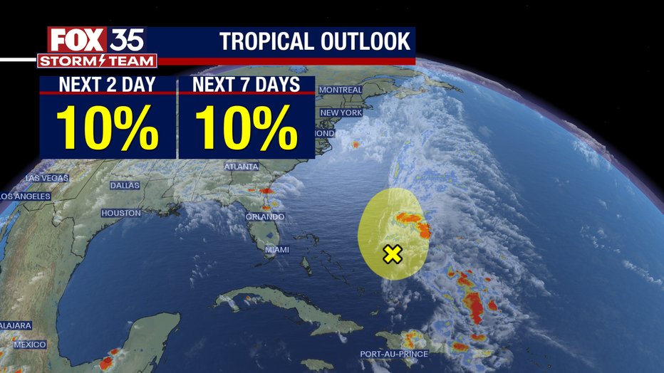
If the development of a low-pressure system occurs over a warm area of the Atlantic Ocean off the Southeast coast, it’s within the realm of possibility that a weak tropical feature could spin up off the coast later this week or over the Memorial Day weekend.
Impact on drought
Nearly half of Florida is in some form of drought right now, with the worst levels reported along the Gulf coast side of the peninsula from near Cedar Key south to near Fort Myers. It appears most of the rain this week will fall across interior and Atlantic portions of the state, doing little to alleviate the worst of the drought.