2024 hurricane season forecast predicts 'extremely active' season with 5 major hurricanes
Weather forecasters with Colorado State University anticipate the 2024 Atlantic Hurricane Season will be "extremely active," citing record sea surface temperatures as the biggest factor, alongside La Nina development.
Here is a breakdown of what they're expecting – and why. This is the first of four planned hurricane season forecast predictions that Colorado State University intends to release throughout the year.
‘Extremely active’ 2024 hurricane season
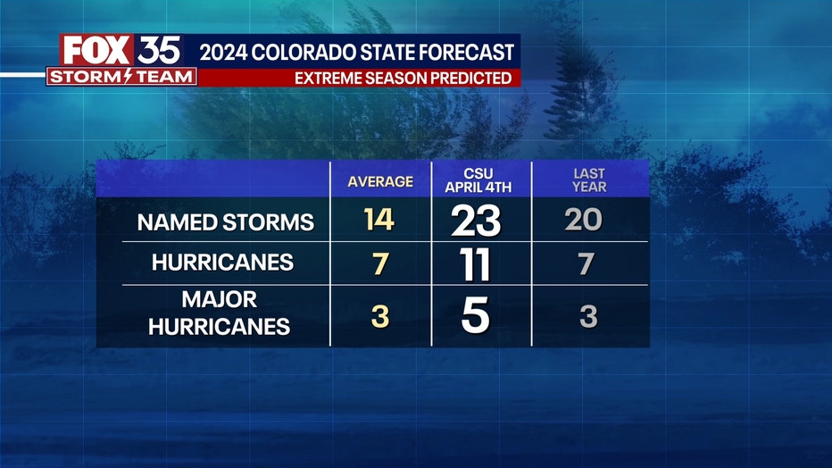
Colorado State University released its prediction for the 2024 Atlantic hurricane season on Thursday, noting that this year's prediction includes the most forecasted hurricanes included in one of its reports:
- 23 named tropical storms
- 11 hurricanes (category 3 or higher)
- 5 major hurricanes

The contributing factors to this extreme season involve two main elements: record-warm waters in the main development region of the Atlantic Ocean and the development of a La Nina.
What is El Nino? What is La Nina? How do both impact possible hurricanes?
The counterpart to El Nino, known as La Nina, is when the eastern equatorial waters of the Pacific off of Ecuador are unusually cool and this leads to impacts all the way over the Atlantic by calming trade winds. These trades can often tear developing hurricanes apart before they form, but this year we may not have that benefit. Lighter winds and warmer water means more storms potentially.
"Given the combined hurricane-favorable signals of an extremely warm Atlantic and a likely developing La Niña, the forecast team has higher-than-normal confidence for an April outlook that the 2024 Atlantic hurricane season will be very active. This is the highest prediction for hurricanes that CSU has ever issued with their April outlook," Colorado State University said in its release.
However, the team also notes that the prediction can shift as the atmosphere and ocean conditions change between April and the start of hurricane season, which runs June 1 - Nov. 30 and the season's peak, which runs August - October.
How does CSU form its hurricane predictions?
Colorado State University uses several statistical models, historical data, as well as model predictions from the European Centre for Medium-Range Weather Forecasts, the UK Met Office, the Japan Meteorological Agency, and the Centro Euro-Mediterraneo sui Cambiamenti Climatici to form its yearly hurricane forecasts.
"These models use 25-40 years of historical hurricane seasons and evaluate conditions including: Atlantic sea surface temperatures, sea level pressures, vertical wind shear levels (the change in wind direction and speed with height in the atmosphere), El Niño (warming of waters in the central and eastern tropical Pacific), and other factors," CSU said.
What are the 2024 Atlantic hurricane season storm names?
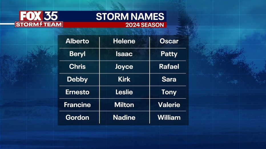
If CSU's prediction proves true – 23 named storms – that would mean every tropical cyclone name for the 2024 season would be used, as well as a couple of names in the supplemental list.

Here are this year's storm names:
- Alberto
- Beryl
- Chris
- Debby
- Ernesto
- Francine
- Gordon
- Helene
- Isaac
- Joyce
- Kirk
- Leslie
- Milton
- Nadine
- Oscar
- Patty
- Rafael
- Sara
- Tony
- Valerie
- William
21 storm names are listed for every tropical/hurricane season and rotate every six years. However, after particularly devastating storms – Katrina (2005), Irana (2011), Sandy (2012), Matthew (2016), Irma (2017), Dorian (2019), Fiona and Ian (2022) – some names will be "retired" and discontinued.

If all of a season's names are used, there is an alternate name list, which includes an additional 21 names. Those names for the Atlantic season include, Adria, Braylen, Caridad, Deshawn, Emery, Foster, Gemma, Heath, Isla, Jacobus, Kenzie, Lucio, Makayla, Nolan, Orlanda, Pax, Ronin, Sophie, Tayshaun, Viviana, and Will.
Hurricane prep: Start now
Colorado State University's prediction is significant because it's the most extreme season they've ever forecasted since releasing their predictions publicly in the 1990s, FOX 35 Meteorlogist Brooks Garner said.
This doesn't mean 23 tropical storms or 11 hurricanes will reach the United States or make landfall in Florida as they can – and often do – curve away. But, more storms does increase the chance of them possibly making landfall.
So, what should you do?
Think about preparing for hurricane season now.
- Do you have an emergency kit or an emergency plan ready? Have you double checked supplies, batteries, or anything you'd need should the power go out for a couple of days or if you need to evacuate?
- Do you know your evacuation zone? Do you know the flood risk for where you live?
- Have you talked with your insurance company to make sure you're protected? Ask the professional about wind coverage and flood coverage.
There are several resources for emergency hurricane tips:

